| Author | Message | ||
Smiley1eye |
Here's a spot for you to share your local (or not local) trip with others. Descriptions are good, maps are better, pictures are best. Put it out there and have some company for that great ride. | ||
Smiley1eye |
If you come to a fork in the road, pick it up. What the heck is a fork doing in the road?!!? Next thing you know, you'll come across a butter knife or a spatula in the road! 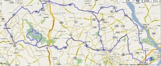 Even though I DO own the road, I'll lend it out to you so you can ride on it. Aren't I kind and benevolent?  | ||
Smiley1eye |
And if you can't read that, blame the limitations on image posting size. I'll email you a better map. | ||
Rasmonis |
Here's my local short circuit. http://maps.google.com/maps/ms?hl=en&ie=UTF8&msa=0 &msid=107505159725656680588.00043c36999d64c369a36& ll=39.377037,-77.287102&spn=0.186034,0.32135&z=12 | ||
Xb12mel |
Here's a good one. Go early to avoid traffic. Caution, this is a fairly "technical" route. Just about 22 miles long. 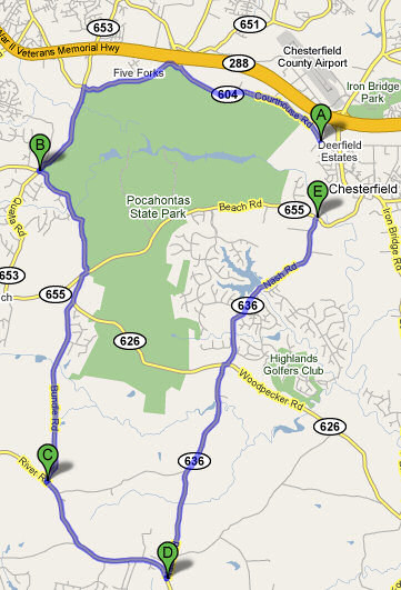 But it should be nothing for all you guys with those dragon stickers on your windscreen!  | ||
Blublak |
I'm working on a bunch of my old ride plans right now.. Doing them on the H-D ride planner and having a pretty good time of it.. most of the time. Will start posting them up once I've got a few done and ready. Maybe we can even tackle a few as a group? There is a killer 2 day run that I think most of you would enjoy called 'Mountain Madness' That I already made public if you wanna check the system out. It's not real intuitive searching, but if you close your search down real small around a small area (in this case Leesburg VA) and click on the 'Roads' icon, it should bring up choices - then you can pull up Mountain Madness and take a look.. Phew.. Ok, I'm going back to work for a few minutes.. | ||
Babired |
Curvy short ride Route 26 west Left on Old Court Rd. Pass the towns Granite and Woodstock Right on Route 99 Right on Route 32 Right on River Rd. Right on Sykesville Main Street Right on Sandusky Rd. Cross Route 32 continue Right on HenryTown Rd. Left onto Marriostville Rd. Right on Hernwood Rd. here is the Road near Woodstock Inn I was talking about on the main thread you guys have to check this one out! | ||
Frinzo |
Any1 have any more good roads to run on? coming back from buelltoberfest 2 and see the roads down there wants me to find some good roads to run on. Maybe i can meet with some of the buellers more in the western/northern part of va  | ||
Babired |
The White's Ferry area is pretty cool on the Maryland side don't know much on the Va. side. And from White's Ferry North west in Maryland the roads are really good. K | ||
Frinzo |
cool, could u send me the direction, going to have to check it out | ||
Babired |
Myron, from Virginia White's Ferry is off of SR 7 and SR 15 it crosses the Potomac River, and you can follow White's Ferry road into Poolsville, Md. If you head Northeast from there you will ride to Sugarloaf Mountain Park and from there if you want something spooky to do head to the original Movie site of the Blair Witch Burkittsville, Md. Not much of a town but its a really nice ride. I stay away from Md SR 270 and just cut West across toward the Potomac. Hagerstown is North where Va route 81 and Md route 340 meet. I tried to send you a link from Google but its not working I haven't figured how to post it. Oh yeah another cool place is Point of Rocks in Maryland K | ||
Thunderstruck |
I'm planning a trip to Senca Rocks WV, leaving Saturday morning and returning Tuesday. Any one have a suggested route that would get me there in a reasonable amount of time but also include some fun scenic riding? While I'm there I plan on taking 55 into Elkins. Looks like it was made for motorcycling. | ||
Blublak |
Hmmmm... On your way back (depending on how much time you have and the weather).. I'm gonna try and send you one of my 'posted' rides.. Like I said, you'll have to 'vary it a little' to continue home bound, but all in all it's doable. | ||
Bearly |
Harrisonburg, then 33 west, through West Virginia for as much fun as you want. | ||
Babired |
Hey Bearly, I was in your neck of the woods 2 weekends ago on Sunday getting a sandwich at the Winchester HD shop. K | ||
Babired |
Yesterday's route on the eastern shore to Hoopers Isle. We had to run through some water on our bikes I rode with 2 BMWs Route thru Blackwater Wildlife Refuge to Old Salty's Restaurant Route 50E to Cambridge, MD R on Bucktown RD L on Decoursy Bridge RD R on Drawbridge RD R on Griffith Neck RD R on Bestpitch Ferry Rd L on Greenbrier Rd L on Maple Dam Rd Continue on Shorters Wharf Bridge L on Andrews *** R on Wesley Church RD L on Toddville RD R on Bishops Head R on Buck Ridge R on Wingate Bishops Head Continue on Lakesville Crapo Rd to 336 Crapo Rd L on Hooper's Island Rd To Old Salty's Restaurant 2560 Hooper's Island Rd, Fishing Creek, MD LUNCH Approx. 43 miles to Oxford, MD - Oxford-Bellevue Ferry Then Home! ***You can cut off a chunk of the route by staying on Andrews Rd, R on Crapo Rd, then L on Hooper's Island Rd | ||
Hooper |
Aha! You found my island! | ||
Babired |
very nice Island except for the guy in the car who would stop in the middle of the water on the road, We finaly rode past him too bad he had his windows down and I'm glad we didn't see him at Old Saltys! The ULY was a water plow! K | ||
B00stzx3 |
Hey K, Whites ferry is where I live now, where I grew up. Its Poolesville, not far at all from germantown/gaithersburg. Poolesvilles is in the Montgomery County agricultural reserve, inlcudes Dickerson, Beallsville, Barnesville, Dawsonville, Poolesville, Boyds and Hyattstown. All the area of northern montgomery up to Frederick county which is like 15 mins from poolesville. Plnety of nice backroads and almost no LEOs. Some speed cameras coming into Poolesville but thats about it because Poolesville has the most population outta all of them. (5000 people!) My aunt lives offa Hernwood road, right next to the abandoned military base. Fave roads- River/seneca road, Germantown road (the woodsy section), Whites Ferry road, Darnestown road (section that goes past QO towards North Potomac) (Message edited by b00stzx3 on January 30, 2009) | ||
Babired |
Hey Bobby, I'd like to ride there, I rode there when I had an Old Yamaha SECA2 I would like to go there again sometime this summer and then go north up to Highrock, where the hang gliders go. That would be a good loop. I love your neck of the woods! We'll have to try and meet up with you and go to HIghrock you would love the roads up there! Right now I have a lot of classes this year we'll see when I get a free weekend we will ride!  | ||
Hooper |
Is Highrock up on the border of MD and PA in Penmar, near Fort Ritchie? If so, it really is incredible. I'd be happy to do a ride there and try to pull a bunch of the DC area riders together for it. | ||
Babired |
Hooper Okay Supafast has the loop route that includes Highrock. I want to go. We rode up there a couple of years ago and I have been wanting to go back ever since. I rode the X1 that day and took some fantastic pictures. I am teaching a lot this year so let me post up some of my free weekends, hoping that we can ride on one of my free weekends. K | ||
Babired |
I'll be seeing Supafast today here are my free weekends: March 21, 22 and 28,29 May 2,3 and 16, 17 and 30, 31 June 6, 7 and 27 28 April I'm traveling and teaching. August I'm riding to Colorado | ||
B00stzx3 |
Sounds good! Warm weather ain't too far off now. Have fun in Colorado. I've always wanted to visit South Park to see if its like the show. | ||
Babired |
Boo I'm taking route 340 to route 50 all the way out going under the major cities, coming back home I'm riding thru Nebraska, Iowa, Wisconsin, Michigan on the north part of the great lakes, down along side of Lake Erie, I think, into Ohio and MD PA I have 3 other lady riders going with me. I'm excited about the trip! South Park I used to watch that! | ||
Babired |
Hooper, here is a link on google maps Higrock is "B" "A" is Poolsville and west of it is White's Ferry. <http://maps.google.com/maps?f=d&source=s_d&saddr=3 9.140712,-77.413788&daddr=Appalachian+Trail&hl=en& geocode=%3BFeiwXQIdyhdh-w&mra=mi&mrsp=0&sz=10&sll= 39.18224,-77.604675&sspn=0.783465,1.7276&ie=UTF8&l l=39.189159,-77.480049&spn=0.097924,0.21595&z=13 | ||
Hooper |
Yep, that's where I thought it was - that is a spectacular place. I never knew it was there until a guy who lives in Middletown took a couple of us around. We blasted through Gambrill and Cunningham Falls State Parks - amazing stuff. Thanks for the map! | ||
Babired |
I loved the ride out there it's been 3 or 4 years now since I've been there. When I got the ULY I was thinking about going to the ORV zone in Greenbrier park. They have a fire trail system there. Here is a pic of the last time I rode to Highrock. 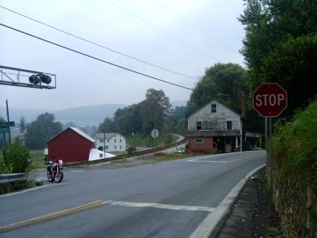 | ||
B00stzx3 |
Thats a heck of a lot of states Kathleen! Local roads, nothing too big but fun nonetheless - River Road (the seneca to poolesville part, not Potomac part), 118/Germantown road (lots of deer and speed camera t the end though), with the exception of all the crappy rough spots and occasional gravel, White Ground rd in germantown/poolesville area. Whites Ferry road has a few cool turns but mostly straights. Good scenery though and Whites Ferry's at the end if you want to head into Virginia/Leesburg. | ||
Hooper |
A couple weekends ago I found some new roads (to me) starting in Germantown, MD, where I encountered a creek crossing and a nice amount of dirt road - perfect for the Uly. If you're not into fording rivers, you could certainly bypass it and take the same roads. From I-270 in Germantown, I took Rt. 121 (Clarksburg Road) west, then the first right on West Old Baltimore Road. It takes you into the woods and down a hill to a dirt/gravel road. Not far along, I encountered a wide stream to cross - it was about 6-7 inches deep with a gravelly bottom. Here's the Uly negotiating the first pass: 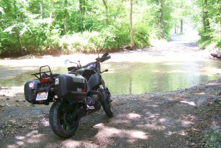 I made it across successfully, baptizing my new Icon Field Armor boots (wet feet). The boots are very cool, more like ski boots, but fit the Uly pretty well and are well-armored/vented, which is vital for the summer. I got off the bike to take a picture, but a jeep came bouncing down the road and I decided I looked like too much of a dink taking a picture of a bike and a creek. They seemed pretty incredulous to see that I had just come across, my muffler steaming away madly. The dirt road continues along cow-filled pastures until the pavement begins again. At Slidell Road I enjoyed this sign:  I soon came to the quaint town of Barnesville, with one of those Civil War Trails signs that I just can't pass up. This part of Maryland has some great history. That presented a great photo op of the Uly, an old red barn, and Sugarloaf Mountain: 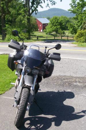 The road becomes Barnesville Road - I took it until it dead-ended into Mt. Ephraim Road (Rt. 95). I took a right on that and headed north towards Sugarloaf Mountain. At the park entrance, I took Sugarloaf Mountain Road through the woods, where it quickly turned into a dirt road - what a blast...just watch out for massive potholes. The dirt road turned back to pavement and intersected with Thurston Road. I turned left (north) on Thurston, which turned out to be a fantastically curvy stretch through trees and farms. Little did I know that Thurston Road would dump me onto Route 80 (Fingerboard Rd) in Urbana, which is a great road by itself. Don't you love those moments when you've just ridden for 30 minutes and you have no idea where you are, but then pop out onto something you know very well? It's now burned into my mental atlas. From there, I buzzed up 80, took a right on Baker Valley Road (through that gorgeous farm valley where much fighting was done during the battle of Fredericksburg), under I-270, left on Araby Church Road, left on Rt. 355 (Urbana Pike) north (remembering that I had recently test-ridden an 1125CR on this route), and into the parking lot of Frederick H-D/B. After lunch in Frederick (at the bar at The Tasting Room), I backtracked the entire way to that creek crossing on West Old Baltimore Road. Time for round 2: 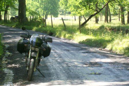 There's nothing like a dirty Uly. I hopped across the creek upstream a bit and set up a camera to capture the action, ran back to the bike, and hit it: 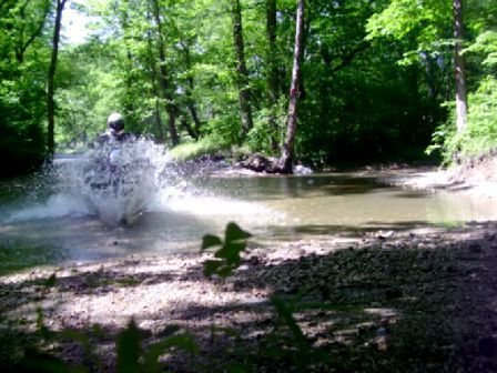 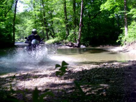 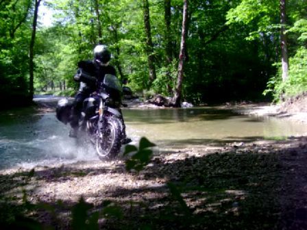 A little more wet this time, and almost wiped out in the gravel on the other side, but nothing gets your adrenaline and sense of adventure pumping than taking a vehicle somewhere where you probably oughtn't, and getting away with it. Tennessee Tuxedo will NOT fail!  (Message edited by hooper on June 19, 2009) |