| Author | Message | ||
Missin44 |
Has anyone used a system other than the Buell Quest unit? At $700 it very pricy for what you get, though I do understand that it comes with al the custom mounting hardware. I know there are other brands/units that will also work well with motorcycles. I would like some input from some of you that have a GPS mounted but decided agianst the Buell Quest unit. Thanks Dave (Message edited by missin44 on April 14, 2006) (Message edited by missin44 on April 14, 2006) (Message edited by missin44 on April 14, 2006) | ||
Brotherbuell |
I use my Garmin 276C on my Uly. It's mounted with a RAM handlebar mount.It's not less expensive but I'm able to use it on the bike, in my car and on my boat since it takes both land and sea maps. I think that's the only way to maximize your GPS investment since they are generally used infrequently. | ||
Rhinowerx |
I use a Garmin 60CS that is now hardwired (pictured using accessory plug)  | ||
Missin44 |
I'm looking at the Quest II or the Garmin 2720. The 2720 I can get everything for about $800 with all the bells an whistles and tons of memory. The Quest II can be had for about $700 with everything, though lacking on some features it is smaller. The Quest doesn't have the memory I'm looking for. Just starting my search though. (Message edited by missin44 on April 14, 2006) | ||
Brotherbuell |
Here's the 276C on my bike. 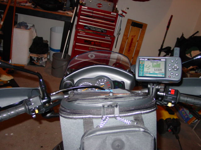 | ||
Henrik |
Someone else recommended the Garmin GPSMAP 60 Cx. Water resistant, new faster processors, new antennas etc. No personal experience, but it seems like a good buy for the price. Of course, the screen is smaller than the "dashboard" type GPS. Jack, do you find the screen on your GPS 60 to be good for turn-by-turn guidance on the motorcycle? Henrik | ||
Jackbequick |
If any of you are using map cases or tank bags with map case tops, a PDA can be a good alternative. Here's an iPAQ in a map case, the GPS receiver lives in the tail housing wrapped in foam rubber. 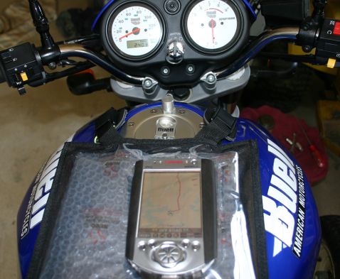 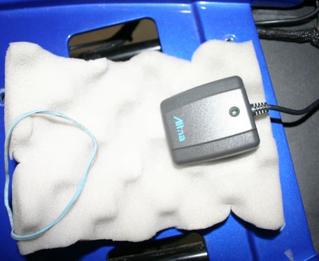 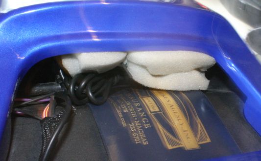 Jack | ||
Cygnus_x1 |
I like the Buell Quest unit, I was going to spend at least 4-5 bills on one of the others, then another $100+ on a mount, plus I would give up the one power outlet on the dash, so I'm liking the Quest. I like the wiring plugs into the factory wiring harness, and it powers down when the key is off. | ||
Skeeter_xb |
This one is about 3 days from going on Ebay if nobody wants it. This has been in the classifieds for about 2 weeks. $190- It is used and in perfect shape. Works great on motorcycles when used with a Ram Mount. E-mail me about additional software! http://65.102.174.119/rammount/productdetail.aspx?partnumber=RAM-B-149Z-GA16U&se archTerm=ga16&item=5 The eTrex Legend® C is Garmin's exciting, new, pocket-sized handheld that brings color, automatic routing, longer battery life, plus more to our popular-selling eTrex Legend. You won’t miss a thing when you take this colorful, lightweight, easy-to-use handheld out hiking, biking, boating or even geocaching. The eTrex Legend C along with the eTrex Vista C are Garmin's smallest, least expensive products to combine a color TFT display and advanced GPS routing capabilities in a waterproof design. Outdoor enthusiasts will love the latest improvements made to the eTrex Legend C: * 256-color, sunlight-readable display makes it easy to distinguish map details and see where you’re going * Automatic route generation, off-route recalculation, turn-by-turn directions with alert tones, and icon-driven menus for finding points of interest (when combined with Garmin’s optional MapSource® CDs) navigate you safely to your destination* * Longer battery life for more hours of outdoor enjoyment * Mini-USB port for fast, convenient download of map data from Garmin’s entire library of optional MapSource CDs using a PC * 24 MB of internal memory for lots of map storage Of course the eTrex Legend C still includes those popular features that users have come to love and expect in the eTrex product line, such as a compact, lightweight, waterproof design and user-friendly interface. The eTrex Legend C is WAAS-enabled, and like all eTrex units, the primary controls are oriented on the side of the unit, so the user can conveniently operate it with one hand. Also, an innovative rocker switch is located on the face of the unit that enables the user to input data easily, scroll through menus, or pan the map page. *When Using City Navigator™ data, unit has limited memory for mapping. Garmin part number: 010-00358-00 Suggested Retail Price: $267.84 U.S.D. (for domestic US market only) | ||
Jackbequick |
The critical detail that someone new to GPS might miss on the units like the Legend C is that the 24mb of memory limits you to traveling with only that amount of optional mapping with street level detail. The built in basemap includes the interstates and all principal highways. "Principal highways" will usually include all national highways and state level numbered highways with one or two digit numbers. To change to another area of detail mapping would require access to a PC with the MapSource package installed. As a pure guess/rough approximation, the 24mb in the Legend C will hold enough detail mapping for a travel radius of a few hundred miles or so. That will vary with the region. The newer Legend Cx (MSRP $321.41) uses microSD cards and that gives it potentially unlimited expansion memory (512mb cards available now, 1Gb and 2Gb cards are on the horizon if not already here). Any of the Garmins with the "x" in the name have removable microSD cards for expansion memory. That feature was a big leap forward for Garmin in the GPS wars, it brought them up to par with the Magellan Meridians. Garmin is now, IMHO, the clear winner on hardware and software features in the handheld GPS wars. Jack | ||
Az_m2 |
I bought the Garmin Quest and mounted it with a RAM mount. Very solid. For power, I use a Y adapter for the power outlet and run it into my tank bag. Plug the Quest in there and still have an outlet for other stuff. I'm very happy with the Quest. $350.00 on eBay delivered w/ warranty. I've heard folks express concern about the limited memory, but it's not an issue for me (on very, very long trips, I bring my laptop). The unit holds plenty of detail map data anyway, I think I loaded detail maps for Arizona, Utah, Colorado, New Mexico, and California with no problem. I also like that you get the Mapsource software for trip planning. I don't think you get it with the Quest II. | ||
Skeeter_xb |
Good points. Using the US Topo software which is very detailed (even has county gravel roads). I can get the entire state of Indiana and a little more on it. I would love to have one of the larger Quest type units but mine serves dual purpose. I need a portable unit that can be used while on foot (military). All just depends on what you'll use it for and how much you want to spend. I even use the Garmin Legend C in my truck. I have a suction cup RAM mount that I put just to the right of my rear view mirror. Works great! | ||
Reepicheep |
The $700 Buell price looks high, but make sure you are comparing apples to apples. I got my Quest (same unit with different boot screen) as a "cheapest I can find". It ended up being a factory refurb from a not that well known dealer for $309. It turned out fine, but thats non trivial risk stacking up there. Add the $15 shipping and you are up to $324. Add in the motorcycle power adapter, and I think you hit close to $400, and I am not sure that includes the $10 RAM quest cradle. You still have to work out where to put everything. Start adding in retail prices, non refurbed unit cost, and engineering time, and warranty support, and the $700 is still "premium" price, but not absurd. Though for that price, it should probably be the Quest II and not the Quest. But to be honest, if somebody offered me either the quest with mapsource, or the quest II alone, I would definately take the quest over the quest II. Henrik, having a highly portable unit for turn by turn driving directions are where the Quest *really* rocks. More reviews and install instructions will be coming soon, but I would highly recommend the unit. Probably not the perfect unit for marine or non road use, but for roads (even unpaved ones) it seems to be very good. I was also amazed to find it works remarkably well as an "I am on the road and need to find X" without having a laptop along. I was not expecting that capability to be useful for anything beyond marketing brochures, but it turns out to be amazingly capable and suprisingly non-annoying. I don't find the "limited" 115Megs of ram to be a big deal. My normal day to day basemap covers everything for a few hundred miles. If I am going to make a road trip, I can plot the route on the laptop, and easily tell Mapsource to download detailed maps for the entire corridor and cities at both ends. It's really nice having a unit so capable that is small enough to put in your pants pocket in a pinch. It also passes the "wife test". I could click a few buttons, load up a route, and put it in the wifes car and send her someplace with a reasonably high confidence it would get her there, even if she had to detour or it plotted a road that did not quite exist. It just works. | ||
Henrik |
Thanks Reep. I'm not seriously shopping, but when I do buy a GPS, I'll want portable and easily move-able between vehicles. I will also want a good amount of storage, for say a 2 week trip from NYC down through the Blue Ridge Mountains with lots of detail in the mountains. I would not want to bring a laptop for uploading maps. Of course great signal reception and quick route re-mapping would be nice too. And for MC use I'll want a water resistant unit with a decent screen - readable even in sunlight. Am I asking too much ....?  Henrik | ||
Reepicheep |
Nope. The quest would probably do all that, the quest II would definitely do it. | ||
Jackbequick |
Henrik, The Quest II has a little more supplemental memory than the Quest (140mb as opposed to 115mb). If you want to carry more street level detail for longer trips and maybe topo maps too, you might look at the 2610 or 2710 StreetPilots as those both have unlimited storage via CF cards. The 2610 in particular has been very well received by motorcyclists. Watch out for any models that have microdrives or hard drives. Those have not done well in high vibration environments. Jack | ||
Garp |
Just to clarify the above post, The Quest II has the entire US pre-loaded, so the 140MB is just needed to add Topo or other map types. Also, while the 2610 is expandable by CF cards, the 2710 is not. Like the Quest II the 2710 has the entire US preloaded. | ||
Csg_inc |
first an E-Map and roll chart 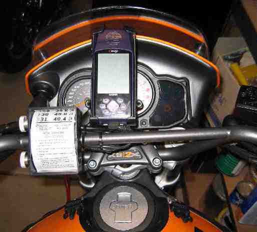 Next a Navigator 2  If you crash the cost to replace the navigator 2 can get pricey. Don't ask. | ||
Aeholton |
I have a Magellan Meridian Gold. It's monochrome, but it was cheap and is water proof. Works great with a 1GB SD card loaded with detailed maps. Here's a picture: 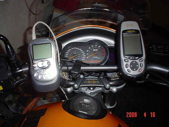 | ||
Jackbequick |
Thanks for un-garbling my post Geoff. I obviously don't have one of everything and thought I had that right. And I conned you into repeating part of my error. There is no model 2710. That should read 2720. So in summary I should have said something like: "If you want to carry more street level detail for longer trips, you might look at the 2610 which has unlimited storage via CF cards or the 2720 which has the detail mapping for the entire U.S. pre-loaded." Thanks again and I hope I have this right now. :>  Jack | ||
Cruisin |
I have a 2610 on my Firebolt and love it. Touch screen, easy to use, and I loaded the entire us (about 1.5gb) on a 2gb flashcard. I don't have to worry about loading maps now. I'm not sure, but I believe any newer Garmin StreetPilot model uses microdrives for their storage. I don't think the mini hard drives were meant to deal with the vibration our bikes have, but I may be wrong. I just know that I liked the idea of a solid state memory. http://www.gpsdiscount.com has some good prices, has refurbs, and all the mounting/wiring you'll need for almost any GPS out there. | ||
Cruisin |
I know it's my Firebolt, but would work equally well on a Uly:  | ||
Jackbequick |
Cruisin - It was the Garmins with the microdrives that were having the failures. The failures were "data read errors" or something like that. I think a soft mounted 2.5" ATA/IDE laptop drive might have a better chance but a bike is still a pretty brutal environment. The microdrives have a CF card footprint/connector and just plug in I guess. Sort of makes you wonder if you can't just replace a 2GB microdrive with a 2GB flash memory card. Jack | ||
Henrik |
A bit of searching and a bunch of reading; found a bunch of interesting stuff about how GPS actually work as well as WAAS concerns etc. The short version: The Garmin 60Cx and the Quest II would likely be my contenders right now. Price difference is not great as you can find a 60Cx w. map package for just a bit less than you'd pay for a Quest II. The 60 Cx has expandable memory, but you will need it for loading maps. It also has better reception under trees or among high rise buildings. It's WAAS enabled, but currently this feature doesn't work well for many. The explanations differ: either the WAAS satellites aren't in their final position or Garmin didn't implement it well. The 60Cx seems to be the better choice if you'll be using it for hiking and such as well as for automotive use. The Quest II has all the detail maps loaded and has 140 MB of extra storage for more maps (topo and such). It has voice prompts via the 12V power cord, but no further expansion of memory should it become necessary (probably not). The voice prompts would make the Quest II the better choice for in particular car use, but if you have sound on your bike the audio out can be wired into your system. Both are water resistant and have same size color screen. Anyway, thanks for all the GPS info and feedback. I'll post more if I decide to take the plunge. Henrik | ||
Reepicheep |
Henrik... Email me a potential trip and I will show you the detailed map footprint that a Quest will be able to load. That will let you put the Quest I into the mix... which I got out the door for $309 + $15 shipping with all map software. With what you get in the quest box, and a $9 RAM mounting bracket, and a scrounged 12V regulator and some simple fabrication, you can have both a portable car and a fixed motorcycle mount all up and running. Good for us cheap-skates. I would agree with your other conclusion, the Quest is tuned for street and known trail use, not back country. | ||
Jackbequick |
Here is a link to Touratech for some pretty nice mounts. You have to click on GPS & Navigation and then GPS Mounts to see them. They have some weirdness in their web page that prevents linking directly. Those mounts are probably not aimed at the "us cheap-skates" market but are nice to look at. And maybe to get some ideas. Jack | ||
Cruisin |
Jack, I believe you're right - those are the errors I recall. Anything from a StreetPilot 2620 and newer uses microdrives. Unfortunately I believe they are internally mounted and thus not swappable. I'm not sure what the quest or quest ii use. The 2610 on my bike has a compact flash slot - it comes with a 128mb card, but is easily upgradable to whatever size (2gb is in mine). The advantage to the Quest is that it has a built in rechargable battery. Nice if you ever want to use it off the bike (like sitting and planning a route, etc). The advantage to the StreetPilot is the bigger screen. I can see a lot of data on mine. There is an audio out plug so I can jack in a headset if I want the audible directions. The Touratech stuff is sweet - especially the locking mounts - it would make me feel more comfortable leaving the GPS on the bike. | ||
Henrik |
Bill: shot you an email. Thanks. I took a closer look at the Quest and Quest II. Other than a few MB of extra storage, what are the big differences? Seems to me they both come with the City Select software preloaded? Both have PC routing capabilities along with re-routing, turn-by-turn directions, voice prompts, WAAS enabled etc. Oh, and Garmin supposedly has made their software Mac compatible - cool  Btw. has anyone tried Google Earth yet? Amazing stuff. Their photos are a year or two years old at least (I know, 'cause the lean-to by my garage in their photo has been gone for over a year, and the new garage roof is light gray, not the old green one that's in the photo  ), but still pretty amazing stuff. They have an upgrade available for $20 which allows you to work with GPS data on the Google Earth views. Wild. ), but still pretty amazing stuff. They have an upgrade available for $20 which allows you to work with GPS data on the Google Earth views. Wild. Henrik | ||
Ksteig |
I use a Tom Tom rider. I like it for road trips. | ||
Court |
Bill: You're pretty sharp on this stuff. Is there a way, hypothetically, I could rig one of these locator devices to help me find Henrik in NYC. I am seeking him and he is avoiding me.  Court P.S. - I'd like to find him but will stop short of having to plant a transmitting device on his person. |