| Author | Message | ||
Jng1226 |
Hi Guys, http://www.youtube.com/watch?v=ssH9JA6ihvo Just got some new video editing software and trying to figure it out. Made a picture-in-picture video of a Deal's Gap run from a couple weeks ago. The main shot is a GoPro HD and the MotoGP butt-cam is a GoPro standard-def. The main video was shot in 1080p but the entire video is only 480 max on YouTube. Still trying to figure it out. How do you embed YouTube videos here? Jeff | ||
Bueller4ever |
Nice! How'd you get the picture at the end? Did you mostly stay in 2nd gear? Anytimes you feel you need to be in 1st? theoretical top speed?  | ||
Spectrum |
Nice! I like the pic-n-pic format. Is that a side arm your wearing? If so, seems like it would be more useful on the clutch hand than the throttle hand. I really enjoyed watching the front suspension articulate. | ||
Aeholton |
Embedded for you. For future reference \youtube then {video #} with no spaces. | ||
Bueller4ever |
Looks like some kind of fanny pack. I don't think you can open carry in NC or TN for that matter. Lot of good a gun in my left hand would do me. I've tried shooting with my left and it ain't happenin. | ||
Hybridmomentspass |
You CAN open carry in NC. I live here. Awesome video, just hate the music on it. No, its a good song, just wish it was just engine noise. | ||
Jng1226 |
Aeholton - thanks for the embedding, I'll try that but I'm not so good at HTML code so it may take a few tries. Bueller4ever - at this pace it's mostly 2nd gear. There's enough torque to pull out of most tight corners. I think the lower gearing of a 1125CR would be perfect for the Gap. The picture at the end is from one of the roadside photographers. There are 3-4 main companies that take pictures of everything that goes through the Gap and sell them on websites: US129photos.com, killboy.com, zeefoto.com, and moonshinephoto.com. Spectrum & Bueller4ever - That is a Maxpedition Thermite waistpack. It has a semi-waterproof compartment on the inside and I use it to carry my Spot GPS, phone, wallet and visor cleaning stuff when riding in the mountains, instead of a cumbersome backpack. At home in FL I do actually use it to carry a S&W M&P Compact but don't really feel the need in the mountains nor do I want the extra weight. I've debated which side to carry it on and I think being able to pull the clutch in and have it on the strong-side is best, because you can still brake with your right foot. Here are some pictures from the roadside photographers on that day: 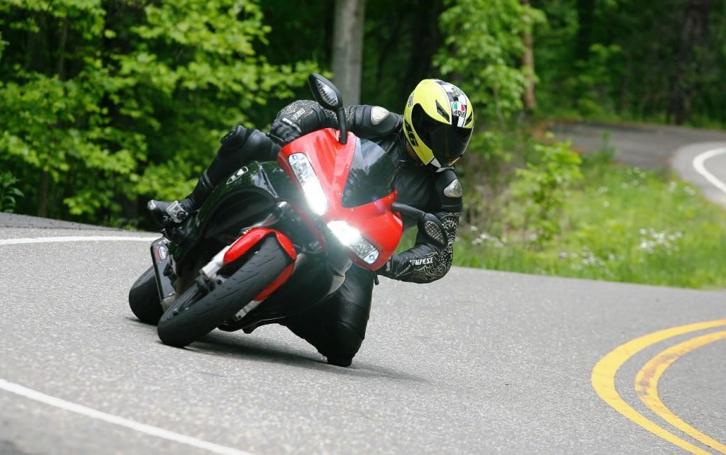 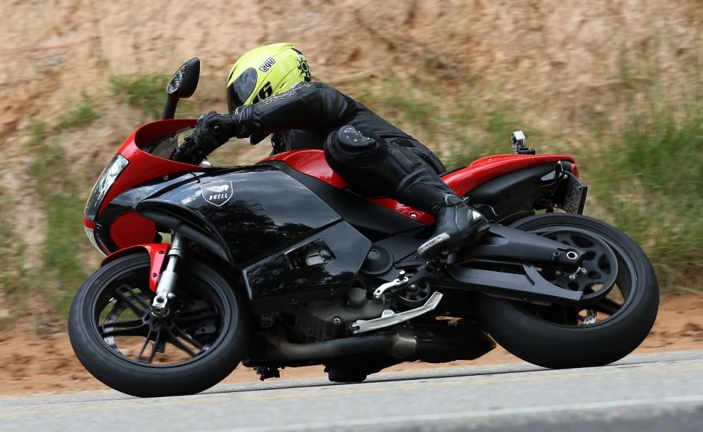 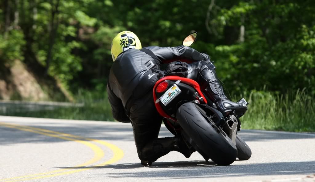 | ||
Bueller4ever |
You CAN open carry in NC. I did not know that. S&W M&P 9c is a great gun. | ||
Joshinga |
I thought this looked familiar.  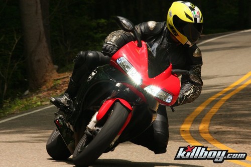 | ||
Jrfitzny |
sweeeeet video. I especially enjoyed the Harley passing  | ||
Jng1226 |
Joshinga - that's funny you saw that. Were you there that week? Jeff | ||
Hogzilla |
Very cool vid. Loved the sparks shooting out in the turns. That foot view camera is WAY close to the ground in the turns. How did you mount those cameras? | ||
Joshinga |
No I look at killboy's site weekly to see the highlights so of the pic's are really good/funny. Thats where I found the pic few people commented about how the black on red look good. | ||
Pegasusrider |
Looks fun! I'm headed there at the end of next week, can't wait. Any advise? Must see stops or LEO heavy spots? | ||
Dannybuell |
Jng1226 - Nice vacation from all the rain in Oregon THX | ||
Jng1226 |
Hogzilla - I used the GoPro suction cup mounts on the side fairing and the tail section. The tail section is curved on the top and I was a bit worried but those suction cups are professional grade. I used those cameras for about a 1,000 miles in rain and sunshine on bumpy roads. I kept expecting to look down and for one to be gone but they held on tight and took great video. View the video above on YouTube and look at my other videos from the same trip, the held on through some pretty hard riding! Pegasusrider - there are so many freakin' good roads up there that it is just ridiculous. Literally go to Google Maps and just find the twistiest lines on the maps in a 100 mile radius and you won't go wrong. I would recommend the Blue Ridge Parkway from Cherokee/Maggie Valley going West (about 34 miles) then go South down the mountain on 215 (about 20 miles) until you hit 64. Then take 64 East back through Cashiers and Highlands back to 441. You can go North on 441 and you've done a big loop of some of the greatest motorcycling roads on all of the earth. From 441 and 64 you can go north on 441 and turn at Franklin, NC and then take 28 North (for a short while connecting on 74 West before resuming 28 North) for about 45 miles all the way to the Deal's Gap resort (where the picture at the beginning of the video was taken). Lastly, a run up and down Blood Mountain in North GA is a must. It is Highway 19 near Vogel State Park. From there take Highway 180 West to T.W.O. - Two Wheels Only resort (http://www.twowheelsonly.com/) which is a great meeting place for motorcyclist and take highway 60 north back to NC and areas near the Gap. Or from Blood Mountain you can go to Helen, GA, and get some good dinner at the various Bavarian themed joints there in a village that looks transplanted from the Swiss Alps. I could keep going and going... It is heaven up there! Regarding cops - the common local knowledge is that most cops that patrol the heaviest trafficked roads leave at around 4-5pm in the afternoon. You have the roads to yourself after that, and is when you'll see all the locals come out to play. Have fun and take pictures, or better yet, video to share on here. One more picture: 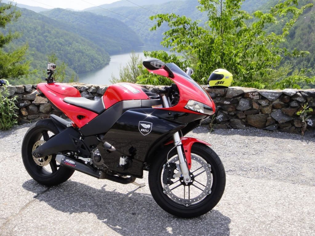 Jeff | ||
D_adams |
What did you keep scraping on the right handers? It almost looked like the camera touching down some but it didn't fall off or vibrate too much from it, so I'm guessing it was something else. | ||
Bueller4ever |
He was scraping his knee!  | ||
Hogzilla |
Looks like metal posts embedded in the pucks. Not sure how functional they are but they look kick ass on camera! Thanks for the info Jng1226! | ||
Pegasusrider |
Thanks for the tips, I'll be planning my route this weekend. | ||
Jng1226 |
Pegasusrider - I re-read my route in the post above and made a mistake. I meant take the Blue Ridge Parkway from Cherokee/Maggie Valley EAST (towards Asheville), not West. You'll go about 34 miles and then take 215 down the mountain (the Parkway runs on top of the mountain) to 64, which you take back West towards/through Sapphire, Cashiers and Highlands. Highlands is a high-end community in the mountains and is a good place to stop for lunch outside. Also, when going EAST on the Blue Ridge Parkway from Cherokee about 2 miles before you reach 215, you'll reach the perfect picture opportunity at the official Highest Point of the Blue Ridge Parkway. Here is a picture of my XB9SX and my buddy Sam's XB12S from the Orlando Buell Club trip up there last spring:  Jeff | ||
Dragstang |
thanks for posting the video and the pics. your bike sounds awesome! randy | ||
Pegasusrider |
Thanks Jeff. I had a great trip! I'll post up details in the Tale Section tonight. |